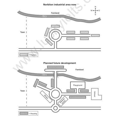
the map below show an industrial area in the town of Norbition and planned future development of the site
A full IELTS Academic Writing Task 1 answer to this mixed / multiple charts at Band 6.0, 7.0, 8.5, with the four-part structure, the comparison language it needs, and why each version scores what it does.
The question
You should spend about 20 minutes on this task.
the map below show an industrial area in the town of Norbition and planned future development of the site.
Summarise the information by selecting and reporting the main features, and make comparisons where relevant.
Write at least 150 words.
The Norbiton industrial area as it is now and the planned future development of the site.
What to select from this mixed / multiple charts
This is a change-of-use map rather than an expansion one: almost every factory becomes housing on roughly the same ground, so the site is being converted rather than extended. Two things are worth catching. The new facilities — shops, medical centre, playground, school — are exactly what a residential population needs, so they follow from the housing rather than being separate additions. And a new road is built north across the river, which is the only change to the layout itself.
Structure
Introduction — Paraphrase: what the two maps show, and note that the second is a proposal.
Overview — No detail: the industrial site is to be converted to residential use, with factories replaced by housing and community facilities added, plus one new road crossing the river.
Body 1 — The change of use — factories giving way to housing around the roundabout.
Body 2 — The new facilities and the new road, and what remains unchanged.
Model answers
Band 6.0 model answer
186 words
The two maps show the industrial area of Norbiton now and the plan for the future.
At the moment there is a roundabout in the middle of the area. There are many factories around it: one on the west, four on the east and one on the north. In the north there is a river and farmland, and in the west there is the town.
In the future most of the factories will disappear. Instead of them, there will be housing. Two houses will be built in the north-west, and more housing will be built in the east near the roundabout.
There will also be new buildings for people. There will be shops on the west side of the roundabout, a medical centre on the south side, a playground in the east and a school in the far east.
Another change is a new road. This road will go to the north from the roundabout and it will cross the river to the farmland.
In conclusion, this industrial area will become a place where people live, with houses, a school and other services instead of factories.
Why this is Band 6.0
All the main proposed changes are identified, which secures Task Achievement at this level.
Changes are listed rather than grouped, and future forms are used inconsistently.
Vocabulary is adequate but repetitive: built, will be and there is carry most of the meaning.
Prepositions of place are limited and sentence structures are mainly simple.
Band 7.0 model answer
212 words
The two maps compare the Norbiton industrial area as it currently stands with the development proposed for the site.
Overall, the area is to be converted from industrial to residential use. Almost all of the existing factories are to be replaced by housing, and a range of community amenities will be provided alongside it, while a new road is planned to the north.
At present the site is organised around a central roundabout, with a single factory to its north-west and a cluster of five arranged in rows to the east. The river and farmland lie beyond to the north, and the town is situated to the west.
Under the plan the great majority of these factories will be demolished and housing built in their place, both to the north-west of the roundabout and along the eastern approach. Only one factory appears to be retained. A number of facilities serving the new residents will also be constructed: shops immediately west of the roundabout, a medical centre to its south, a playground to the east and a school at the far eastern edge of the site. In addition, a new road will run northwards from the roundabout, crossing the river into the farmland beyond — the only alteration to the road layout itself.
Why this is Band 7.0
The overview is separate, arrives early and identifies the change of use as the defining feature.
Changes are grouped into conversion and new provision, and future forms are used consistently.
Less common lexis is used accurately: converted, residential, amenities, retained.
Prepositions of place are more varied: to the north of, adjacent to, either side of.
Band 8.5 model answer
265 words
The two maps compare the present layout of the Norbiton industrial area with the development proposed for the same site.
Overall, the plan converts an industrial estate into a residential district. The factories are to be cleared and housing built largely on their footprint, with the accompanying shops, school, medical centre and playground provided because of that new population rather than as separate developments. Only the road network is genuinely extended.
The site is currently arranged around a central roundabout, from which a road runs east. A single factory stands to the north-west of this junction and a further cluster of five occupies the ground to the east, laid out in parallel rows. Beyond them the river separates the area from farmland to the north, while the town lies off the map to the west.
The proposal removes almost all of this industry. Housing is to be constructed north-west of the roundabout, where one factory presently stands, and along both sides of the eastern road in place of the cluster there, with a single factory apparently surviving. Around this new housing a set of amenities will be added: shops on the western approach to the roundabout, a medical centre to its south, a playground among the eastern housing and a school at the far eastern boundary.
The one change to the site's structure is a new arterial road running due north from the roundabout and crossing the river into the farmland, which opens up access in the only direction currently closed off. The river, the farmland and the position of the town itself remain unaltered.
Why this is Band 8.5
The overview names the change of use and notes that the facilities follow from the housing rather than being independent additions.
Groups the proposals by what they achieve, giving the description a logic the map does not label.
Identifies the new road as the sole structural change and locates it precisely.
Lexis is precise and economical: converted, residential, amenities, footprint, arterial.
Complex structures are used flexibly, including a fronted concessive, an appositive and a participle clause, with no strain.
Model answers written and reviewed by The English All-in-One IELTS team. They are teaching models showing what each band looks like, not real candidate scripts.
This is a mixed / multiple charts question. The answers above show you what each band looks like when it is finished. What they cannot show you is how to get there from a blank page in forty minutes.
That is what our Writing Study Library is for: the structure we teach for this exact question type, the paragraph pattern that goes with it, and the sentence openers for each stage — so the essay is planned before you start writing rather than assembled as you go.
What is the difference between a change-of-use map and an expansion map?
On an expansion map the town grows into new land; here the same ground is reused for a different purpose. Saying which kind you are describing in the overview immediately shows you have understood the plan rather than simply spotted new buildings.
Should I say why the new facilities are being built?
You can note that the shops, school and medical centre accompany the housing, since that relationship is visible in the plan. Speculating about council policy or demand would be going beyond it.
How do I describe several similar buildings?
Group them and describe their arrangement: "a cluster of five arranged in parallel rows to the east". Naming each factory separately would use the same words to convey less, and grouping is what selection means on a map.
What tense should I use for a proposal?
Future and modal passives — <em>are to be cleared</em>, <em>will be constructed</em>, <em>is planned</em> — with present simple for the existing map. Mixing the two, or describing a proposal in the past, is the most common accuracy error on this task type.