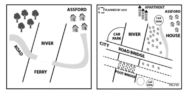
The diagram below shows the development of a particular area between 1965 and the present day
A full IELTS Academic Writing Task 1 answer to this map at Band 6.0, 7.0, 8.5, with the four-part structure, the comparison language it needs, and why each version scores what it does.
The question
You should spend about 20 minutes on this task.
The diagram below shows the development of a particular area between 1965 and the present day.
Summarise the information by selecting and reporting the main features, and make comparisons where relevant.
Write at least 150 words.
The development of an area either side of a river between 1965 and the present day.
What to select from this map
Two things make this map unusual. The river crossing changes character completely — a ferry becomes a road bridge, which is what makes all the other development possible — and the second map contains a planned feature as well as existing ones, marked by a dashed outline. Handling that third time frame correctly, with future language for the foot bridge, is what separates a careful answer from a rushed one.
Structure
Introduction — Paraphrase: what the two maps show, and note that the second includes planned as well as existing features.
Overview — No detail: the area has been heavily developed, with the ferry replaced by a road bridge, woodland cleared and housing greatly expanded, plus one further crossing still planned.
Body 1 — The crossings and the road — ferry to bridge, and the planned foot bridge.
Body 2 — The land either side — woodland cleared, housing expanded, apartments and car parks added.
Model answers
Band 6.0 model answer
181 words
The two maps show an area with a river in 1965 and today. There were many changes in this area.
In 1965 there was a ferry to cross the river, and there was a road on the west side. On the east side there was a small village called Assford with only four houses, and there was a forest in the north-west.
Today the ferry does not exist anymore. Instead of the ferry, a road bridge was built across the river, so cars can cross it. There is also a plan to build a foot bridge in the south by 2010.
The forest in the north-west was cut down, and now there is a car park in this place. On the east side of the river many more houses were built, and there are apartments in the north with another car park.
There are also two more car parks in the south, near the new foot bridge.
In conclusion, this area changed from a small quiet place with a ferry into a town with a bridge, many houses and car parks.
Why this is Band 6.0
The main changes are identified, which secures Task Achievement at this level.
The planned foot bridge is mentioned but not clearly distinguished from features that already exist.
Vocabulary is adequate but repetitive: built, now and there are carry most of the meaning.
Prepositions of place are limited and sentence structures are mainly simple.
Band 7.0 model answer
216 words
The two maps compare an area on both sides of a river as it was in 1965 and as it is today, the second map also showing one feature planned for completion by 2010.
Overall, the area has been developed extensively. The most consequential change is the replacement of the ferry by a road bridge, which has been accompanied by the clearing of woodland and a large expansion of housing on the eastern bank.
In 1965 the only way across the river was a ferry, running between the road on the western side and the small settlement of Assford on the east. This has since been removed and a road bridge constructed in its place, linking the city on the west directly to the residential area opposite. A second crossing, a foot bridge, is proposed further south and is shown as planned rather than built.
The land on both banks has changed considerably. The woodland that occupied the north-west in 1965 has been cleared and a car park now stands there. On the eastern side, Assford has grown from four isolated houses into an extensive residential area, with a block of apartments and a further car park added to the north. Two more car parks are shown in the south, close to the proposed foot bridge.
Why this is Band 7.0
The overview is separate, arrives early and identifies the bridge as the change that enabled the rest.
The planned foot bridge is distinguished from existing features by tense.
The passive is used consistently and changes are grouped by area.
Less common lexis is used accurately: cleared, residential, crossing, proposed.
Band 8.5 model answer
269 words
The two maps compare an area either side of a river in 1965 with its present-day layout, the current map additionally showing one feature that was planned for completion by 2010 rather than built.
Overall, the area has been transformed from a largely rural setting into a developed one, and almost all of that change follows from a single decision: replacing the ferry with a permanent road crossing. Woodland has been cleared, housing has expanded substantially on the eastern bank, and parking provision has appeared where none existed.
In 1965 the river could be crossed only by ferry, which connected a road on the western bank to the small settlement of Assford opposite, where just four houses stood. The ferry has since been superseded by a road bridge running east to west across the river, giving direct vehicular access between the city on the western side and the housing on the eastern. A second crossing for pedestrians is marked further south, shown by a dashed outline and therefore proposed rather than existing.
Both banks have been developed in consequence. The woodland that covered the north-west has been cleared entirely and replaced by a car park, while the western side is now labelled as city. On the eastern bank, Assford has expanded from a handful of dwellings into a dense ribbon of housing extending along and below the new bridge, with apartment blocks and a further car park added at the northern end. Two additional car parks are planned near the foot bridge in the south, so that every crossing point on the current map has parking attached to it.
Why this is Band 8.5
The overview identifies the bridge as the enabling change rather than merely the largest one, which explains the pattern of everything else.
Handles three time frames correctly — 1965, the present, and the 2010 proposal — with the tense shifting appropriately.
Groups the changes by function and notes what the pattern of car parks implies about how the area is now used.
Lexis is precise and economical: crossing, cleared, ribbon of housing, proposed, superseded.
Complex structures are used flexibly, including a fronted concessive, an appositive and a participle clause, with no strain.
Model answers written and reviewed by The English All-in-One IELTS team. They are teaching models showing what each band looks like, not real candidate scripts.
This is a map question. The answers above show you what each band looks like when it is finished. What they cannot show you is how to get there from a blank page in forty minutes.
That is what our Writing Study Library is for: the structure we teach for this exact question type, the paragraph pattern that goes with it, and the sentence openers for each stage — so the essay is planned before you start writing rather than assembled as you go.
How do I handle a map with a planned feature on it?
Treat it as a third time frame and mark it in your language: <em>is proposed</em>, <em>was planned for completion by 2010</em>, <em>shown as planned rather than built</em>. Describing a dashed outline as though it already exists is a factual error the examiner can see.
Should I say which change caused the others?
You can note that the bridge made the rest possible where the maps clearly support it — housing appears on the far bank only after direct road access exists. Keep it as an observation about the layout rather than a claim about planning decisions.
How do I describe the size of a housing area?
Compare it with what was there before and use language that conveys density: "expanded from four houses into an extensive residential area". A count in 1965 against a described spread today is more informative than either figure alone.
Is it worth noticing a repeated feature like car parks?
Yes — spotting that every crossing now has parking attached is a pattern rather than a list, and patterns are what selection means on a map task. It also gives your final sentence something to do besides summarising.