
Map Task 1 Academic

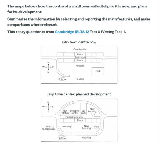
The maps below show the centre of a small town called lslip as it is now, and plans for its development

A full IELTS Academic Writing Task 1 answer to this map at Band 6.0, 7.0, 8.5, with the four-part structure, the comparison language it needs, and why each version scores what it does.

The question

You should spend about 20 minutes on this task.

The maps below show the centre of a small town called lslip as it is now, and plans for its development.

Summarise the information by selecting and reporting the main features, and make comparisons where relevant.

Write at least 150 words.

Two maps of the town centre of Islip as it is now and as planned. Currently a main road runs east to west with shops on both sides, housing to the south, a park to the east and a school to the south-west. The plan pedestrianises the main road, encircles the town with a new dual carriageway, replaces countryside to the north with a bus station, shopping centre and car park, and adds new housing while retaining the park and school.
The centre of Islip as it is now, and the plans for its development.

What to select from this map

A present-versus-future map, so the tense changes: the existing map is present simple and the plan is future or modal — <em>will be built</em>, <em>is to be replaced</em>. Organise by what happens to each area rather than by walking round the page. The two features that carry the answer are the pedestrianisation of the main road combined with the new ring road, and the loss of the countryside to the north; the park and school being untouched is worth one clause.

Structure

Introduction — Paraphrase: what the two maps show and that the second is a proposal rather than a record.

Overview — No detail: the town is to be expanded and reorganised around traffic, with the central road closed to cars and a ring road built, while the north loses its countryside to new facilities.

Body 1 — Roads and the town centre — pedestrianisation and the new dual carriageway.

Body 2 — The buildings — new facilities and housing to the north, and the features left unchanged.

Model answers

Band 6.0 model answer

200 words

The two maps show the centre of a small town called Islip now and the plan for the future.

At the moment there is a main road in the middle of the town from west to east. There are shops on both sides of this road. In the north there is countryside, and in the south there is housing. There is also a park in the east and a school in the south-west.

In the future the main road will be only for pedestrians, so cars cannot use it. A new dual carriageway will be built around the town, so the traffic will go around the centre and not through it.

The countryside in the north will disappear. In this place they will build a bus station, a shopping centre and a car park. New housing will also be built in the north-east and in the middle of the town.

Some things will not change. The park will stay in the east, the school will stay in the south-west, and the shops on the south side of the road will also stay.

In conclusion, the town will become bigger and the centre will be much better for people who walk.

Why this is Band 6.0

  • All the main proposed changes are identified, which secures Task Achievement at this level.
  • Changes are listed one after another rather than grouped, and the distinction between present and planned is not always maintained by tense.
  • Vocabulary is adequate but repetitive: built, new and there will be carry most of the meaning.
  • Prepositions of place are limited, and sentence structures are mainly simple and compound.

Band 7.0 model answer

241 words

The two maps compare the centre of the small town of Islip as it exists today with the changes proposed for its development.

Overall, the town is to be substantially reorganised around the movement of traffic, with the central road closed to vehicles and a new road built to carry them around the town instead. The area of countryside to the north will be given over to new facilities and housing, while the park and the school are to be retained unchanged.

The most significant proposal concerns the roads. At present a main road runs east to west directly through the centre, with shops lining both sides of it. Under the plan this stretch is to be pedestrianised, and a new dual carriageway will be constructed encircling the town centre, so that through traffic no longer passes between the two rows of shops.

The northern part of the site will change beyond recognition. The countryside currently occupying it is to be replaced by a bus station, a shopping centre and a car park, arranged along the northern edge of the pedestrianised street, with new housing built to the east of these. Further new housing will appear in the centre of the town, next to the existing park. Elsewhere the layout is preserved: the shops on the southern side of the road, the housing to the south, the park in the east and the school in the south-west all remain in place.

Why this is Band 7.0

  • The overview is separate, arrives early and identifies the reorganisation around traffic as the main change.
  • Changes are grouped by area, and the planned map is consistently handled with future forms and passives.
  • Less common lexis is used accurately: pedestrianised, dual carriageway, retained, relocated.
  • Prepositions of place are more varied: to the north of, encircling, adjacent to.

Band 8.5 model answer

286 words

The two maps compare the present centre of the small town of Islip with the layout proposed for its development.

Overall, the plan reconfigures the town around a single principle: removing through traffic from the centre and rerouting it around the outside. This is accompanied by a significant expansion northwards, where open countryside is to be given over to transport and retail facilities, while the school and the park are preserved in their current positions.

The road network accounts for the most consequential change. At present a main road runs east to west through the middle of the town, with shops on both of its sides, so that vehicles pass directly between them. Under the proposal this central stretch is to become pedestrians only, and a new dual carriageway will be built as a loop encircling the whole town centre, entered from the west. The effect is to convert what is currently a road with shops on it into an enclosed shopping street with no vehicle access at all.

The northern edge of the town will be developed most heavily. The countryside that occupies it now is to be replaced by three new facilities set along the top of the pedestrianised area — a bus station, a shopping centre and a car park — with new housing constructed immediately to their east, in the north-eastern corner of the site.

Elsewhere the changes are additive rather than disruptive. A further block of new housing is to be built in the centre, immediately west of the existing park, while the shops on the southern side of the street, the housing along the southern edge, the park itself and the school in the south-west are all retained without alteration.

Why this is Band 8.5

  • The overview captures the logic of the plan — traffic removed from the centre and rerouted around it — rather than listing individual buildings.
  • Groups changes by function (roads, then buildings) and closes each with what is unchanged, so continuity is reported as well as change.
  • Maintains a clean tense distinction between the existing map and the proposal throughout.
  • Lexis is precise and economical: pedestrianised, through traffic, encircling, given over to, preserved, reconfigured.
  • Complex structures are used flexibly, including a fronted concessive, an appositive and a participle clause, with no strain.

Model answers written and reviewed by The English All-in-One IELTS team. They are teaching models showing what each band looks like, not real candidate scripts.

This is a map question. The answers above show you what each band looks like when it is finished. What they cannot show you is how to get there from a blank page in forty minutes.

That is what our Writing Study Library is for: the structure we teach for this exact question type, the paragraph pattern that goes with it, and the sentence openers for each stage — so the essay is planned before you start writing rather than assembled as you go.

See the structure for this question type →

Vocabulary for this topic

Word or phraseMeaningUsed in a sentence
to pedestrianiseto close a street to vehicles so only people on foot may use itThe central stretch is to be pedestrianised.
dual carriagewaya road with two lanes in each direction separated by a barrierA new dual carriageway will encircle the town.
through trafficvehicles passing through rather than stoppingThe plan removes through traffic from the centre.
to encircleto form a ring around somethingThe new road encircles the town centre.
to be given over toto be converted for a different useThe countryside is to be given over to new facilities.
to be retainedto be kept unchangedThe park and the school are to be retained.
to reconfigureto reorganise the arrangement of somethingThe plan reconfigures the town around traffic flow.
additiveadding to what exists rather than removing itElsewhere the changes are additive rather than disruptive.

Write your own answer

Draft your response below, then get it marked against all four IELTS criteria. Your draft stays in this browser — nothing is published.

Common questions

What tense do I use when the second map is a plan?

Future forms and passives for the proposal — <em>will be built</em>, <em>is to be replaced</em>, <em>are to be retained</em> — and present simple for the existing map. Describing a proposal in the past tense is a factual error and one examiners notice immediately on this type.

Should I mention things that stay the same?

Yes, briefly. On a map task, continuity is part of the comparison, and an answer that reports only the new buildings leaves the reader unsure whether everything else survived. One sentence listing the retained features is proportionate.

How do I organise a map with many changes?

Group them by function or by area rather than by position on the page. Here, roads belong in one paragraph and buildings in another, which lets you explain the logic of the plan instead of walking the reader around the map at random.

Can I say what the plan is trying to achieve?

You can describe the effect where it follows directly from the maps — closing the road to cars and building a bypass plainly removes through traffic from the centre. What you should avoid is speculating about intentions, cost or whether the plan is a good idea.